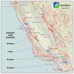
• Bine ati venit! Acesta este noul server al forumului Cutremur.net!

Cutremurele din California

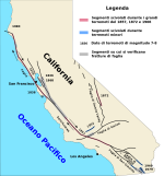
O alta imagine a faliilor principale din California, corelate cu unele cutremure mai semnificative:

956px-San_Andreas_Fault_Map_IT.svg.png
Sursa: https://es.wikipedia.org/wiki/Archivo:San_Andreas_Fault_Map_IT.svg

Cutremurul de ieri pare a se fi produs pe un sistem de falii corelat cu falia San Andreas si cu falia Garlock. Pe 21 iulie 1952, un cutremur major cu magnitudinea Mw 7,3-7,5 s-a produs pe o falie paralela cu Garlock (pe falia White Wolf, se pare). Cutremurul din 1952 a afectat regiunea Kern County.
 
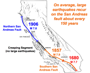
Cel mai puternic cutremur produs in California a fost generat de ruperea unui segment sudic masiv al faliei San Andreas la 9 ianuarie 1857: cutremurul de la Fort Tejon, cotat cu o magnitudine Mw 7,9. Acest mare cutremur a fost, se pare, cam de 2-3 ori mai puternic decat seismul de la San Francisco de la 18 aprilie 1906 (care a rupt un segment nordic al faliei San Andreas). Ceea ce asteapta de fapt americanii pe falia San Andreas este un mare cutremur in partea sudica a faliei SA, deci ceva in genul cutremurului din 1857. Cutremurul din 1857 a rupt un segment sudic al faliei SA, cu lungimea de aprox. 350 km, de la Parkfield la Wrightwood. Desi epicentrul a fost localizat in zona Parkfield, el este referit sub numele de "cutremurul de la Fort Tejon" deoarece aceasta a fost localitatea in care s-au inregistrat cele mai mari distrugeri.
Dupa marele cutremur din 1857, in zona Parkfield s-au produs numai cutremure cu magnitudini in jur de 6,0, la intervale aproape standard de 15-32 ani: 1881, 1901, 1922, 1934, 1966. S-a estimat o perioada medie de revenire de cca. 22 de ani. Dupa seismul din 1966, urmatorul cutremur cu magnitudinea 6 pe segmentul Parkfield al faliei SA era asteptat in jurul anului 1988 (an de referinta), cu o marja de +/-5 ani. Experimentul Parkfield a constat intr-o prognoza pe termen lung combinata cu monitorizarea in timp real a unor parametri geofizici si a deformarilor crustei terestre, a temperaturii apelor freatice in zona faliei etc. Esec total, cutremurul Parkfield mult-asteptat de americani in jurul anului 1988 nu a venit in fereastra de timp asteptata. Cutremurul a venit pana la urma, dar mult mai tarziu decat il asteptau seismologii: la 28 septembrie 2004! De ce oare ? Poate ca si din cauza cutremurului de la Coalinga din 2 mai 1983, care a impiedicat, se pare, propagarea tensiunilor si concentrarea acestora pe segmentul Parkfield al faliei SA. Acum segmentul Parkfield se apropie de expirarea intervalului standard de pauza, practic incepe o fereastra de timp cu mare probabilitate pentru urmatorul cutremur cu magnitudinea 6. Vine sau nu vine ? Vine in urmatorii 5 ani sau se repeta istoria si iar intarzie cu 10-15 ani ? Si ce l-ar putea intarzia ? Seismologii acorda un mare interes cutremurelor de la Parkfield, pentru ca se crede ca unul dintre urmatoarele cutremure de pe acest segment al faliei SA ar putea declansa un mare cutremur in Sudul Californiei, prin ruperea masiva a partii sudice a faliei SA, deci cu un eveniment in genul celui din 1857. Deci vine sau nu vine cutremur la Parkfield, pe segment sudic al faliei San Andreas, in urmatorii ani ?
 
Doar ca a venit abia la 28 septembrie 2004, totusi semnificativ mai tarziu decat il asteptau americanii. E drept, a mai fost o pauza relativ mare intre 1934 si 1966, deci exista niste antecedente pentru unele intarzieri.
 
http://hts/southern-california-m-6-4...ruptures-8976/
Southern California M 6.4 earthquake stressed by two large historic ruptures


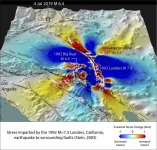
The site of the 4th of July shock was stressed by the great 1872 Owens Valley quake and the 1992 Landers quake. Their overlapping stress lobes may have raised the stakes for this region.

Temblor-map-4-July-2019-shock-1024x974.jpg


The Eastern California Shear Zone lights up

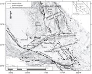
The quake lies west of Searles Valley and east of Ridgecrest, near the Naval Air Warfare Center on China Lake. This is a region of diffuse shear and extension, as indicated by the myriad of small distributed faults, and is part of the so-called ?Eastern California Shear Zone.? It also lies close to a geothermally active region that heats and locally thins the crust. While the San Andreas is the major fault system that accommodates the Pacific-North America plate motion, the Eastern California Shear Zone plays a secondary role, and so, in fact, the plate boundary spans the entire girth of California.

Two quakes gang up in Ridgecrest

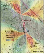
We calculate that two large earthquakes, the 26 March 1872 M~7.6 Owens Valley shock, and the 29 June 1992 M=7.3 Landers shock, permanently imparted stress to the site of today?s shock, perhaps increasing the likelihood of earthquakes in this region over others.

1872-stress-transfer-842x1024.jpg

The more recent 1992 M 7.3 Landers shock was followed by the Ridgecrest earthquakes of M 5.4 in August 1995, and an M 5.8 in September 1995 (Hauksson et al., 1995). These earthquakes perhaps indicate that stress imparted by the Landers earthquake immediately brought this area closer to failure, and so the 1995 events might be regarded as remote aftershocks.

LND-stress-4-July-2019-Searles-Lk-quake-1024x982.jpg
 
Un alt articol din aceeasi sursa completare pentru al doilea cutremur.

http://temblor.net/earthquake-insigh...rs-later-9041/
Magnitude 7.1 earthquake rips northwest from the M6.4 just 34 hours later


The M 6.4 earthquake loaded the site where the M 7.1 shock nucleated. Now, the M 7.1 has extended the original rupture to the northwest, as well as to the southeast, where it kisses the major Garlock Fault.

Rupture of a Previously Unknown Fault

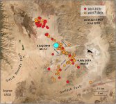
The town of Ridgecrest was not done shaking after a magnitude 6.4 earthquake on the morning of July 4. An M=7.1 shock ruptured for at least 35 km (20 mi) from the 4 July 2019 epicenter, towards the northwest, and perhaps also for 25 km to the southeast. It is astonishing that there is no continuous mapped fault at the ground surface, despite the near absence of vegetation that can otherwise hide faults. Numerous other faults have been mapped in this region, trending predominantly in a north-south direction, somewhat different than this earthquake. The aftershock alignment, however, is very straight in a northwest-southeast trend, suggesting that beneath the surface must lie a continuous fault. We strongly suspect that the rupture is right-lateral (whichever side you are on, the other moves to the right). The trend is parallel to the San Andreas Fault, but has a strike (or compass orientation) more westerly than most of the nearby surrounding faults.

1.jpg
Aici se vad pozitiile celor doua epicentre, in raport si cu falia Garlock, asupra careia unii specialisti atrag atentia.
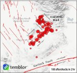
O alta harta:

2.jpg

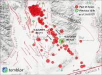
This Temblor app map with another 2 hours of events gives a different impression of the M 7.1 aftershocks than the initial USGS map, suggesting that the rupture does not simply extend to the northwest. Based on these aftershocks it appears ?bilateral?, meaning that the fault unzipped both to the northwest and southwest, for a total length of up to 55 km. This would be more consistent with its magnitude, as a strike-slip M 7.1 typically has a length of about 50 km. If this is correct, then parts of the Garlock Fault might also be brought closer to failure.

Deci semne de intrebare ar fi in legatura cu potentialul faliei Garlock.

ridgecrest_coulomb_7pt1_emsc.png

Aftershocks Propagating Towards the Garlock Fault


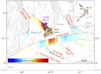
Seismicity between the M=7.1 at 8:19pm and midnight (local) has continued to the northwest and southeast. At the time of writing, 12:10am (local) the closest aftershock is within a few kilometers of the nearby Garlock Fault, which runs east-west between the Eastern California Shear Zone and the San Andreas Fault. Changes in stress on this major fault can have major implications for the nearby city of Los Angeles, and so will be closely monitored in the coming days.
 
Back
Sus