• Bine ati venit! Acesta este noul server al forumului Cutremur.net!

Astazi in istoria seismica globala

nelu1

New member
Înscris
27 Feb 2013
Mesaje
147
Scor reacție
0
In acest subiect propun sa discutam, "la zi", despre evenimentele seismice nationale si internationale de insemnatate care au avut loc in trecut.


Exact acum 28 de ani, in 19 septembrie 1985, in statul Michoacan din sud-vestul Mexicului s-a produs unul dintre cele mai mortale cutremure ce au avut loc pe glob. Cutremurul, generat pe falia cu acelasi nume, Michoachan, a avut magnitudinea de 8 Ml (8,3 Mw) si s-a produs la o adancime intre 15 si 28 km, in functie de sursa. Atunci au murit peste 9500 de persoane, iar 30000 au fost ranite. Peste 100000 de oameni au ramas fara case. Aceste detalii difera putin, in functie de sursa. Unii apreciaza ca au existat 40000 de victime (decese). Au fost semnalate distrugeri importante in capitala Ciudad de Mexico (Mexico City), dar si in alte zone din centrul Mexicului, distrugeri ce au totalizat aproximativ 4 mld. $.
Ca fapt divers, un bazin de inot, aflat la 2000 km distanta, de la Universitatea Arizonei din Tucson, a pierdut o cantitate de apa datorita seiselor formate de miscarea telurica.
 

Atașamente

  • Michoac?n M?xico.png
    Michoac?n M?xico.png
    19 KB · Vizualizări: 1
Bune idee, nelu. Vom rememora evenimentele seismice mai semnificative produse pe plan global in fiecare zi, dupa caz. Eu primesc de la grupurile de la Yahoo la care sunt abonat remindere cu seisme puternice consemnate in lume in anumite zile, in special in ultimii 100 de ani. Si le voi insera aici.
 
Am adus unele completari.
Date mai gasim si pe USGS sau wikipedia.
 
Title: 1989 Loma Prieta Earthquake

Date: Thursday October 17, 2013
Time: 5:00 pm - 5:00 pm (GMT-08.00) Pacific Time (US & Canada)
Location: Santa Cruz Mountains/Bay Area
Notes: At 5:04 P.M. on Tuesday, October 17, 1989, a powerful M7.1 earthquake rocked Northern California's Bay Area caused by a bilateral rupture of the Santa Cruz Mountains segment of the San Andreas Fault.
This quake killed 63 people and injured over 3700.

The single greatest tragedy in this quake was the collapse of the Nimitz Freeway (I-880) double-decked freeway structure
which killed 42 people.

The other notable incident in this quake was the huge block-sized fire in the Marina which raged for hours after the quake and took a significant amount of the S.F.F.D. to stop.
This fire occurred on the fill created by pushing the rubble of the 1906 earthquake into the shallows of San Francisco Bay.

This disaster caused up to $12 billion in damage which at the time made it the costliest disaster in U.S. history.

This quake famously occurred near the start of Game Three of of the "Bays Ball" World Series between the Oakland A's and the San Francisco Giants which series was delayed by the quake but Oakland ultimately swept 4-0.

De pe grupul de discutii californiadisasters (Yahoo).
 
Astazi se implinesc 20 de ani de la cutremurul puternic care a afectat regiunea Los Angeles la 17 ianuarie 1994, cu epicentrul in zona Northridge. Seismul a avut loc dimineata, la ora 4h31min, magnitudinea acestuia fiind de 6,7 grade pe scara bazata pe moment seismic. A fost cel mai puternic cutremur care a afectat marele bazin Los Angeles de la seismul produs la Sylmar-muntii San Gabriel la 9 februarie 1971 (magnitudine 6,6).

Cutremurul din 17 ianuarie 1994, Los Angeles

Epicentrul cutremurului a fost localizat in partea central-nordica a vaii San Fernando din regiunea metropolitana Los Angeles; acceleratia maxima a miscarii pamantului a fost una dintre cele mai mari inregistrate instrumental intr-o zona urbana din America de Nord. Seismul a fost resimtit pana la Las Vegas, in statul Nevada, la aproape 360 km de epicentru. S-au inregistrat si 2 post-socuri mai puternice, cu magnitudini moment de 6,0 grade, prima la un minut dupa socul initial principal si a doua la interval de 11 ore; in afara acestora, s-au mai produs mai multe sute de replici moderate si slabe.
In urma cutremurului au murit 57 de oameni, iar alti 5000 au fost raniti. Cutremurul a provocat importante pagube materiale, intre care distrugerea mai multor segmente de autostrazi suspendate.

800px-FEMA_-_1807_-_Photograph_by_Robert_A._Eplett_taken_on_01-17-1994_in_California.jpg


800px-Street_Damage_After_Northridge_Earthquake.jpg


Seismul a avut epicentrul localizat in Valea San Fernando, la cca. 30 km de zona centrala a metropolei. Adancimea focarului a fost de 18 km. Cutremurul a avut o intensitate maxima de cca. IX grade pe scara Mercalli in zona epicentrala.

13600sm.jpg


In afara de prabusirea mai multor segmente ale unor autostrazi suspendate, cutremurul a mai afectat serios si alte elemente de infrastructura: cladiri de locuinte, spitale, cai rutiere terestre, cai feroviare, institutii de invatamant.

800px-Kaiser_Permanente_Building_After_Northridge_Earthquake.jpg


398px-FEMA_-_13623_-_Photograph_by_FEMA_News_Photo_taken_on_01-17-1994_in_California.jpg


northridgeEarthquake_FEMAandreaBooher250px_1.jpg


Au izbucnit si mai multe incendii, cauzate inclusiv de distrugerea unor conducte de alimentare cu gaze.

090125.Northridge.EQ.jpg


northridge_onpage.jpg


Iata deci un cutremur care, dupa standardele din California, nu a fost prea mare, magnitudinea fiind comparabila cu a precedentului seism puternic din regiunea Los Angeles produs in anul 1971, dar care a avut urmari destul de severe in zona metropolitana. Los Angeles pare a avea un risc seismic mai ridicat in legatura mai ales cu unele falii locale si regionale, care pot fi chiar mai periculoase pentru metropola decat "celebra" San Andreas, care de fapt nu trece prin Los Angeles.
 
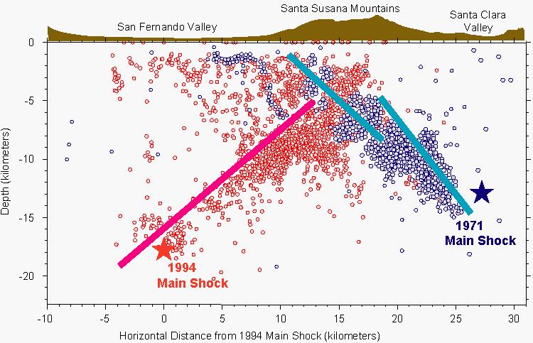
Aici avem locatiile hipocentrelor celor 2 cutremure puternice din Valea San Fernando-Los Angeles, California: 9 februarie 1971 Sylmar Mw=6,6 si 17 ianuarie 1994 Mw=6,7.

p20study.jpg


Sursa: USGS Response to an Urban Earthquake -- Northridge '94

Studying the Setting and Consequences of the Earthquake


Sunt reprezentate focarele socurilor principale dar si distributia replicilor. Sunt trasate planele de falie ale cutremurelor din 1971 si 1994. Se pare ca in 1994 ruptura s-a terminat la cca. 5 km adancime, foarte aproape de o falie care s-a rupt in 1971.


Dupa cum se arata in materialul citat, cutremurul din 17 ianuarie 1994 de la Northridge, Los Angeles, a inceput prin ruperea unei falii "ascunse" la o adancime de aprox. 17,5 km sub Valea San Fernando. Intr-un interval de 8 secunde de la momentul cedarii initiale, ruptura s-a propagat ascendent si catre nord-vest in lungul planului de falie, cu o viteza de aprox. 3 km/sec !!!! Ruptura din scoarta terestra s-a terminat, se pare, la o adancime de 
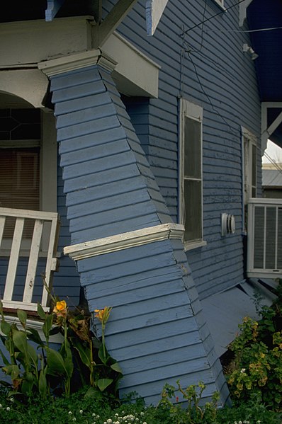
5-6 km. Eu cred ca si aceasta propagare ascendenta foarte rapida a contribuit la efectele severe ale cutremurului in sectorul Northridge. Cele mai spectaculoase distrugeri au fost, fara indoiala, prabusirile acelor segmente de autostrazi suspendate.

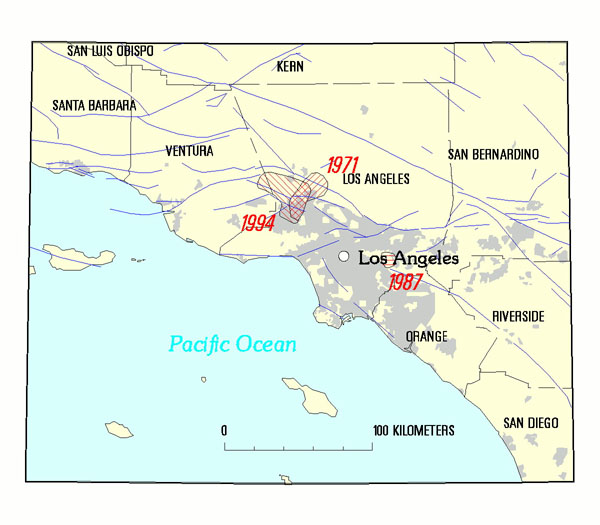
In imaginea de mai jos

flteqvga.jpg


avem locatiile epicentrelor celor 3 cutremure mai importante care au afectat zona Los Angeles in ultimii 40 de ani: 1971 (San Fernando-Sylmar, Mw=6,6-6,7); 1987 (Whittier Narrows , Mw=5,9) si 1994 (San Fernando-Northridge, Mw=6,7). Se observa o anumita suprapunere intre zonele rupte in 1971 si 1994 !!!! Cutremurul din 1987 s-a produs pe o falie "oarba", dar a avut o magnitudine semnificativ mai mica.
Conform solutiei de mecanism de focar determinate pentru acest eveniment, in dimineata zilei de 17 ianuarie 1994, miscarile asociate rupturii pe falia de la Northridge au fost constituite din cel putin 3 subevenimente consecutive, rapid succedate, in interval de cateva secunde. Subevenimentul initial a fost reprezentat de ruperea unei asperitati si a inceput chiar in hipocentrul determinat instrumental pentru acest cutremur, proces care s-a extins foarte repede in directie ascendenta. Un al doilea subeveniment mare a fost localizat la cca. 12 km in directie oblic-ascendenta spre nord fata de hipocentrul initial al cutremurului. Un al 3-lea subeveniment s-a declansat la aproximativ 19 km adancime la 8 km vest-nord-vest de hipocentrul initial. Iata, prin urmare, un eveniment de tip MULTI-SOC!!!! He, he, unde am mai intalnit un MULTI-SOC ??? Ghiciti cine mai da MULTI-SOCURI. Pai e evident: 1977, Vrancea. Iata ca, in unele aspecte, Vrancea produce cutremure care, desi aparent unice, in realitate prezinta, uneori, caracteristici similare unor cutremure din California. MULTI-SOCURI!!!

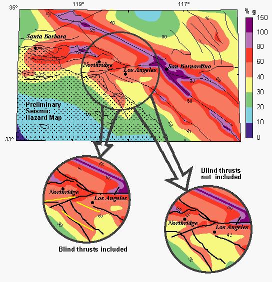
Aici avem o alta reprezentare a bazinului Los Angeles, cu si fara marcarea faliilor ascunse de la Northridge, una dintre ele fiind, se pare, la originea cutremurului de acum 20 de ani.

p54study.jpg


Sursa: USGS Response to an Urban Earthquake -- Northridge '94

Earthquake Hazards Assessment--
Seismic-Hazards Maps for the Los Angeles Region


In material se atrage atentia asupra faliilor ascunse ("oarbe") care ar mari hazardul seismic pentru regiunea Los Angeles. Totusi, intervalul de recurenta al evenimentelor semnificative este lung, chiar mai lung decat se estima initial.
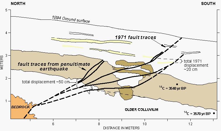
Dupa cutremurul Sylmar-San Fernando de la 9 februarie 1971, cercetatorii au examinat atent falia Sierra Madre.

p55study.jpg


Atunci s-a apreciat ca precedentul eveniment puternic pe acelasi segment de falie avusese loc cu cca. 200 de ani inainte. Dupa cutremurul Northridge de la 17 ianuarie 1994, cercetatorii au reevaluat datele si configuratia geotectonica locala si au ajuns la concluzia ca, de fapt, precedentul eveniment major de pe sistemul de falii San Fernando-Los Angeles avusese loc cu mult mai mult de 200 de ani in urma. S-ar parea ca pe segmentul Sylmar (care a generat seismul din 1971), numai 2 cutremure puternice s-au produs in ultimii 3.500-4.000 de ani, unul dintre ele fiind cutremurul de 6,6-6,7 grade din 9 februarie 1971.
 
M7,25-7,5 I=IX (h=7 km) - Marea Egee, 1968
Cape Tripiti, Grecia

https://goo.gl/maps/oXrEz
Resimtit pe o arie larga de 950000 km2, pana in Bulgaria, la Sofia sau Plovdiv si pana in Turcia, la Bursa, Istanbul, Eskisehir, Izmir etc., cutremurul a provocat:
-20 de morti, 18 grav raniti, 21 usor raniti
-500 cladiri distruse, 1951 cladiri grav avariate
-pagube estimate: 600000 $
 
Astazi se implinesc 50 de ani de la megaseismul de magnitudine moment 9,2 produs in anul 1964 in Alaska.

50 years ago, Great Alaska Earthquake tore up southern Alaska, sent out deadly tsunamis

Sursa: http://www.foxnews.com/us/2014/03/2...uake-tore-up-southern-alaska-sent-out-deadly/

Great%20Alaska%20Earthquake.JPEG


Cutremurul a afectat mai violent zona Anchorage si a provocat si un tsunami catastrofal. Dupa cum au relatat cei care au simtit seismul, miscarea violenta a durat 4 pana la 5 minute!!!

Cateva detalii despre Marele cutremur din Alaska de la 27 martie 196a gasim aici: 1964 Alaska earthquake

AlaskaQuake-FourthAve.jpg


A fost un megaseism de subductie, care pe langa tsunami, a provocat si fenomene importante de lichefiere la Anchorage.
 
Multumim real pentru reminder. O sa discutam intr-un topic separat despre acele megaseisme, pe care le consider deosebit de importante si interesante; cred ca au avut un impact global si ca au influentat o anume dinamica. Nu prea am avut timp ieri, din motive obiective, dar diseara vom crea topicul respectiv. Sau il creez acum si o sa detaliem diseara, acum nu prea am timp asa...
 
Rectific: exista deja un topic la sectiunea de stiri, il voi relua insa intr-un context mai larg la Cutremure din lume.
 
Astazi se implineste 1 an de la marele cutremur din zona Khash-Saravan, sud-estul Iranului si granita cu Pakistanul, produs la 16 aprilie 2013. A fost un cutremur subcrustal major, de magnitudine Mw 7,7 si adancime focala 80-90 km, cel mai mare seism produs in Iran in ultimii 40 ani, alaturi de cutremurul de la Tabas din 16 septembrie 1978.
Cateva detalii despre acest cutremur major gasim aici:

2013 Sistan and Baluchestan earthquake

Iata si efectele macroseismice ale seismului, pe harta de la USGS (intensitati):

2013_iran_pakistan_earthquake.jpg


Cutremurul s-a produs in zona de subductie a placii Arabiei sub cea Euro-Asiatica. Ne amintim ca pe 18 ianuarie 2011, un alt cutremur subcrustal major, de magnitudine 7,2, s-a produs pe partea pakistaneza, in zona Dalbandin, tot la 80-90 km adancime: 2011 Pakistan earthquake

Cele 2 cutremure subcrustale majore sunt legate, evident, de zona de subductie Makran.
In ceea ce priveste tectonica Iranului, se stie ca stramtoarea Hormuz separa 2 forme de coliziune de placi tectonice:

Arabian_tectonic_plate_overview_map.gif


-pe de o parte, spre nord-vest avem sectoare de crusta continentala apartinand placilor Araba si Euro-Asiatica intr-un proces de coliziune, in lungul unei zone compresive (linia Zagros, care a generat si seismul de magnitudine 6,3 din 9 aprilie 2013, eveniment care a precedat marele cutremur din 16 aprilie 2013 din Makran);
-pe de alta parte, la sud-est, blocul crustal oceanic al placii Arabice se subduce, aproape orizontal, sub placa Euro-Asiatica in lungul liniei Makran.
 
Este interesant ca acest cutremur mare s-a produs la aproape 1 an de la megaseismele din 11 aprilie 2012 produse langa Sumatra pe Ninety Ridge, a se vedea topicul Megaseismele din Ninety Ridge-Sumatra de la 11 aprilie 2012 . De asemenea, dupa acest mare cutremur au urmat seismele puternice din sud-vestul Pakistanului din 24/28 septembrie 2013 (pe segmente sudice ale sistemului tectonic al faliei Chaman).
 
Astazi se implinesc 108 ani de la marele cutremur din 1906 care a distrus San Francisco.

Reminder from: californiasearthquakeforum Yahoo Group

Title: 1906 7.8 San Francisco Earthquake and Fire

Date: Friday April 18, 2014
Time: 12:15 am - 12:15 am (GMT-08.00) Pacific Time (US & Canada)
Notes: This earthquake was one of the most devastating in the history of California. With the fires caused by, as estimated at this time, 3000 died and there was $524 million in property loss. Damage in San Francisco resulting only from the earthquake was estimated at $20 million; outside the city, it was estimated at $4 million. The duration of the shaking in San Francisco was about 1 minute.

Though earthquake damaged buildings and structures in all parts of the city and county of San Francisco, over much of the area, the damage was moderate in amount. It was in the business district, which was built on ground made by filling in the cove of Yerba Buena, pavements were buckled and fissured. The brick and frame houses, ordinary construction of that time, were damaged extensively or destroyed. Sewers and water mains were broken and streetcar tracks were bent into wavelike forms.

On or near the San Andreas fault, buildings were destroyed, and trees were knocked to the ground. The surface of the ground was torn into furrowed ridges. Roads crossing the faultline were impassable, and pipelines were broken. One pipeline that carried water from San Andreas Lake to San Francisco was broken, shutting off the water supply to the city. The fires that ignited soon after the earthquake quickly raged through the city because of this and destroyed a large part of San Francisco and intensified the loss at Fort Bragg and Santa Rosa.

The earthquake caused the most lengthy rupture of a fault that has been observed in the contiguous United States. Displacement of the San Andreas Fault was observed over a distance of 185 miles from San Juan Bautista to Point Arena, where is passes out to sea. As displacement was observed farther north at Shelter Cove and as now assumed, the rupture was continuous, makes the total length of rupture over 267 miles. The -felt- area included most of CA and parts of western Nevada and southern Oregon.and southern Oregon.


Alte informatii gasim aici:

1906 San Francisco earthquake

800px-Post-and-Grant-Avenue.-Look.jpg


Distributia efectelor macroseismice (intensitati), conform USGS:

1906_Boatwright_intensity.jpg
 
Reminder from: WorldEarthquakes Yahoo Group

Title: M 7.2 Dilman, IRAN, 1930

Date: Tuesday May 6, 2014
Time: 12:00 am - 12:00 am (GMT) Greenwich Mean Time - Dublin / Edinburgh / Lisbon / London
Notes: One of the world's deadliest earthquakes. Over 2,500 dead. About 60 villages destroyed in the Salmas Plain and surrounding mountains. The town of Dilman (population 18,000) was completely destroyed, but there were only 1,100 deaths because a magnitude 5.4 foreshock had occurred at 07:03 UTC. Although the foreshock killed 25 people, it probably saved thousands of lives since many people chose to sleep outdoors that night. Faulting was observed on the Salmas and Derik Faults, with the maximum offsets 5 m (16 ft) vertically and 4 m (13 ft) horizontally
on the Salmas Fault. Dilman was rebuilt west of the ruins
and named Shahpur, now Salmas.
 
Reminder from: WorldEarthquakes Yahoo Group

Title: Mw 7.9 2008 EASTERN SICHUAN, CHINA

Date: Monday May 12, 2014
Time: 12:00 am - 12:00 am (GMT-08.00) Pacific Time (US & Canada)
Location: Eastern Sichuan, CHINA
Notes: The Sichuan earthquake of 12 May 2008, 06:28:01.58
UTC, occurred as the result of motion on a NE
striking reverse fault or thrust fault on the
northwestern margin of the Sichuan Basin. The
earthquake's epicenter (30.969, 103.186) and
focal-mechanism at a depth of 16 km are consistent
with it having occurred as the result of movement
on the Longmenshan fault or a tectonically related
fault. The quake reflects tectonic stresses
resulting from the convergence of crustal material
slowly moving from the high Tibetan Plateau, on
the west, eastward against strong crust underlying
the Sichuan Basin and southeastern China.

About 1.5 km of surface faulting was observed
near Qingchuan, and surface cracks and fractures
occurred on 3 mountains in the area; and
subsidence and street cracks were observed in
the city. Maximum intensity XI was assigned in
the Wenchuan area. Beichuan, Dujiangyan, Wuolong
and Yingxiu were almost completely destroyed.

There were at least 69,195 documented fatalities,
374,177 injured and 18,392 missing and presumed
dead in the Chengdu-Lixian-Guangyuan area. The
quake is reported to have killed 5,335 students
(reported earlier as 19,065 confirmed dead) and
left another 546 children disabled. At least
15 million people were evacuated from their
homes and more than 5 million were left homeless.

At least 45.5 million people in 10 provinces and
regions were affected, and about 5.36 million
buildings collapsed and 21 million buildings were
damaged.

The total economic loss was estimated at 86
billion (US dollars).

At least 700 were buried by a landslide at
Qingchuan. Landslides dammed several rivers,
creating 34 barrier lakes which threatened
about 700,000 people downstream. A train was
buried by a landslide near Longnan, Gansu. At
least 2,473 dams sustained some damage and more
than 53,000 km of roads and 48,000 km of tap
water pipelines were damaged.
 
Reminder from: WorldEarthquakes Yahoo Group

Title: Chilean earthquake, 1960

Date: Thursday May 22, 2014
Time: 12:00 am - 12:00 am (GMT) Greenwich Mean Time - Dublin / Edinburgh / Lisbon / London
Notes: Recognising the biggest recorded earthquake known to man.


Pe 21 mai 1960 s-a produs in Chile cel mai mare cutremur inregistrat instrumental, magnitudinea acestuia fiind de 9,5 grade Mw.

Voi reveni diseara cu mai multe detalii.
 
91 de ani de la marele cutremur Kanto din Japonia, produs la 1 septembrie 1923, de magnitudine 7,9-8,3. Seismul a distrus capitala Tokyo, dar a afectat si alte localitati, intre care Yokohama.

1923 Great Kant? earthquake

The earthquake had a magnitude of 7.9 on the Moment magnitude scale (Mw),[3] with its focus deep beneath Izu ?shima Island in the Sagami Bay. The cause was a rupture of part of the convergent boundary where the Philippine Sea Plate is subducting beneath the Okhotsk Plate along the line of the Sagami Trough.[4]

k01_lga00004.jpg


1923 Kanto Earthquake: Echoes From Japan's Past
 
Reminder from: WorldEarthquakes Yahoo Group

Title: Mw 7.8 Tabas, IRAN - 16 SEP 1978

Date: Tuesday September 16, 2014
Time: 12:30 am - 1:30 am (GMT-08.00) Pacific Time (US & Canada)
Location: Tabas, IRAN & vicinity
Notes: This was one of the world's deadliest earthquakes.
The earthquake was centered about 600 kilometers
southeast of Tehran in the vicinity of Tabas. The
death toll was about 15,000, many were injured,
and the damage was extensive. Tabas had the highest
death toll - 9,000 killed out of a population
of 13,000, Dehesk had 2500 killed out of 3500,
and Kurit had 2000 killed out of 3500; the
remainder of the deaths were in surrounding
areas.


Revin diseara cu ceva detalii despre acest cutremur catastrofal.
 
Back
Sus