• Bine ati venit! Acesta este noul server al forumului Cutremur.net!

Astazi in istoria seismica globala

Astazi se implinesc 66 de ani de la devastatorul seism din 1948 din Turkmenistan.
Seismul, cu magnitudinea M 7.3, a provocat moartea a cel putin 110000 persoane, iar in orasul si capitala Ashgabat si in satele apropiate mai toate cladirile din caramida s-au prabusit. De asemenea morti si pagube insemnate au fost consemnate si in Iran.
https://goo.gl/maps/vZPlI
 
Acum 9 ani a avut loc marele cutremur din Pakistan, zona Kashmir, de magnitudine moment 7,6 grade, cu urmari foarte grave in Pakistan si Afganistan.


[email protected]

2005 A major earthquake occurred about 95 km (60 miles) north-northeast of Islamabad, Pakistan At least 86,000 people killed, more than 69,000 injured and extensive damage in northern Pakistan. The heaviest damage occurred in the Muzaffarabad area, Kashmir where entire villages were destroyed and at Uri where 80 percent of the town was destroyed. At least 32,335 buildings collapsed in Anantnag, Baramula, Jammu and Srinagar, Kashmir. Buildings collapsed in Abbottabad, Gujranwala, Gujrat, Islamabad, Lahore and Rawalpindi, Pakistan. Maximum intensity VIII. Felt (VII) at Topi; (VI) at Islamabad, Peshawar and Rawalpindi; (V) at Faisalabad and Lahore. Felt at Chakwal, Jhang, Sargodha and as far as Quetta. At least 1,350 people killed and 6,266 injured in India. Felt (V) at Chandigarh and New Delhi; (IV) at Delhi and Gurgaon, India. Felt in Gujarat, Haryana, Himachal Pradesh, Madhya Pradesh, Punjab, Rajasthan, Uttaranchal and Uttar Pradesh, India. At least one person killed and some buildings collapsed in Afghanistan. Felt (IV) at Kabul and (III) at Bagrami, Afghanistan. An estimated 4 million people in the area left homeless prior to winter. Landslides and rockfalls damaged or destroyed several mountain roads and highways cutting off access to the region for several days. Landslides occurred farther north near the towns of Gilgit and Skardu, Kashmir. Liquefaction and sandblows occurred in the western part of Vale of Kashmir and near Jammu. Landslides and rockfalls also occurred in parts of Himachal Pradesh, India. Seiches were observed in Haryana, Uttar Pradesh and West Bengal, India and many places in Bangladesh.
 
La 17 octombrie 1989 a avut loc cel mai puternic cutremur care a afectat San Francisco dupa marele seism din 1906. Cutremurul a avut magnitudinea de 6,9 grade (Mw).

1989 Loma Prieta earthquake

Se pare ca au existat niste precursori, cu cca. 1-2 ani inainte, in special miscari seismice moderate in vecinatatea segmentului de falie care urma sa se rupa.


The M5.3 June 1988 and the M5.4 August 1989 events (local magnitude) also occurred on previously unknown oblique reverse faults and were within 5 kilometers (3.1 mi) of the M6.9 Loma Prieta mainshock epicenter, near the intersection of the San Andreas and Sargent faults. Total displacement for these shocks was relatively small (about 10 centimeters (3.9 in) of strike-slip and substantially less reverse-slip) and although they occurred on separate faults and well before the mainshock, Perfettini et al. considered these to be foreshocks due to their location in space and time relative to the main event. Each event's aftershock sequence and impact on stress drop was closely examined, and the results of their study indicated that the shocks did have an impact on the mainshock's rupture process. Following the August 8, 1989 shock, in anticipation of an upcoming large earthquake, staff at the University of California, Santa Cruz deployed four accelerometers in the area, which were positioned at the UCSC campus, two residences in Santa Cruz, and a home in Los Gatos. Unlike other nearby (high gain) seismographs that were overwhelmed (driven off scale) by the large magnitude mainshock, the four accelerometers captured a useful record of the main event and more than half an hour of the early aftershock activity.[6][10]

The June 27, 1988 shock occurred with a maximum intensity of VI (Strong). Its effects included broken windows in Los Gatos, and other light damage in Holy City, where increased flow was observed at a water well. Further away from the Santa Cruz Mountains, pieces of concrete fell from a parking structure at the Sunnyvale Town Center, a two-level shopping mall in Santa Clara County. More moderate damage resulted from the August 8, 1989 shock (intensity VII, Very Strong) when chimneys were toppled in Cupertino, Los Gatos, and Redwood Estates. Other damage included cracked walls and foundations and broken underground pipes. At the office of the Los Gatos City Manager, a window that was cracked had also been broken in the earlier shock. Also in Los Gatos, one man died when he exited a building through a window and fell five stories. The event was followed hours later by a M4.5 aftershock that had a maximum intensity of V (Rather Strong).[1][11]


Cutremurul din octombrie 1989:

 
La 16 decembrie 1920 a avut loc un mare cutremur din China, provincia Gansu. Seismul a provocat alunecari de teren cu urmari catastrofale.


"M 7.8 1920 "Gansu" Earthquake" reminder
When
Tuesday, 16 December 2014
12:00 AM to 12:00 AM
(GMT) Greenwich Mean Time - Dublin / Edinburgh / Lisbon / London
Where
Haiyuan, Ningxia (Ning-hsia), China
Notes
The "Gansu" earthquake caused 200,000 deaths. It caused total destruction (XII - the maximum intensity on the Mercalli scale) in the Lijunbu-Haiyuan-Ganyanchi area. Over 73,000 people were killed in Haiyuan County. A landslide buried the village of Sujiahe in Xiji County. More than 30,000 people were killed in Guyuan County. Nearly all the houses collapsed in the cities of Longde and Huining. Damage (VI-X) occurred in 7 provinces and regions, including the major cities of Lanzhou, Taiyuan, Xi'an, Xining and Yinchuan. It was felt from the Yellow Sea to Qinghai (Tsinghai) Province and from Nei Mongol (Inner Mongolia) south to central Sichuan (Szechwan) Province. About 200 km (125 mi) of surface faulting was seen from Lijunbu through Ganyanchi to Jingtai. There were large numbers of landslides and ground cracks throughout the epicentral area. Some rivers were dammed, others changed course. Seiches from this earthquake were observed in two lakes and three fjords in western Norway. Although usually called the Kansu (now Gansu) earthquake by Western sources, the epicenter and highest intensities are clearly within Ningxia Autonomous Region.


[WorldEarthquakes] M 7.8 1920 "Gansu" Earthquake, Tuesday, 16 December 2014
 
[WorldEarthquakes] New Madrid Quake December 16, 1811, Tuesday, 16 December 2014

Primul mare soc din seria seismelor devastatoare de la New Madrid, Mississippi, din estul Statelor Unite, 1811-1812.

"New Madrid Quake December 16, 1811" reminder
When
Tuesday, 16 December 2014
12:00 AM to 12:00 AM
(GMT) Greenwich Mean Time - Dublin / Edinburgh / Lisbon / London
Where
Northeast Arkansas
Notes
Northeast Arkansas December 16, 1811 - two shocks - Mfa 7.2, MSn 8.5 and Mfa 7.0, MSn 8.0~~Magnitude ~7.2 - 8.1
From
WorldEarthquakes Calendar
 
Astazi se implinesc 10 ani de la megaseismul de 9,1-9,3 grade din Sumatra, Oceanul Indian, cu tsunami catastrofal.

2004 Indian Ocean earthquake and tsunami, it is the third-largest earthquake ever recorded on a seismograph. The earthquake had the longest duration of faulting ever observed, between 8.3 and 10 minutes. It caused the entire planet to vibrate as much as 1 centimetre (0.4 inches)[10] and triggered other earthquakes as far away as Alaska.[11] Its epicentre was between Simeulue and mainland Indonesia.[12] The plight of the affected people and countries prompted a worldwide humanitarian response. In all, the worldwide community donated more than $14 billion (2004 US$) in humanitarian aid.[13]
 
Se implinesc si 11 ani de la cutremurul de la Bam, sud-estul Iranului.

2003 Bam earthquake

Sursa: http://en.wikipedia.org/wiki/2003_Bam_earthquake

The 2003 Bam earthquake struck Bam and the surrounding Kerman province of southeastern Iran at 1:56 AM UTC (5:26 AM Iran Standard Time) on Friday, December 26, 2003. The most widely accepted estimate for the magnitude of the earthquake is a moment magnitude (Mw) of 6.6; estimated by the United States Geological Survey. The earthquake was particularly destructive, with the death toll amounting to 26,271 people and injuring an additional 30,000. The effects of the earthquake were exacerbated by the use of mud brick as the standard construction medium; many of the area's structures did not comply with earthquake regulations set in 1989.
 
Cutremurul major de la Messina, Italia, 28 decembrie 1908

A fost cutremurul cu urmarile cele mai grave produs in Italia in ultimii cca. 120 de ani.

Sursa: 1908 Messina earthquake

The 1908 Messina earthquake (also known as the 1908 Messina and Reggio earthquake[3]) and tsunami took about 123,000 [4] lives on December 28, 1908, in Sicily and Calabria, southern Italy. The major cities of Messina and Reggio Calabria were almost completely destroyed.[1]

On December 28, 1908 from about 05:20 to 05:21 an earthquake of 7.1 on the moment magnitude scale occurred centered on the of city Messina, in Sicily. Reggio on the Italian mainland also suffered heavy damage. The ground shook for some 30 to 40 seconds, and the destruction was felt within a 300-kilometer (186-mile) radius. Moments after the earthquake, a 12-meter (39-foot) tsunami struck nearby coasts, causing even more devastation; 91% of structures in Messina were destroyed and some 70,000 residents were killed.[5] Rescuers searched through the rubble for weeks, and whole families were still being pulled out alive days later, but thousands remained buried there.[6] Buildings in the area had not been constructed for earthquake resistance, having heavy roofs and vulnerable foundations.[7]

The earthquake was caused by normal faulting between plates. Italy sits along the boundary zone of the African Continental plate and this plate is pushing against the seafloor underneath Europe at a rate of 25 millimeters (1 inch) per year. This causes vertical displacement which in turn can cause earthquakes.[8] Recently it has been proposed that the concurrent tsunami was not generated by the earthquake, but rather by a large undersea landslide it triggered. There were also several fires that destroyed houses and turned them to rubble.[9]


Cutremurul a fost urmat si de un tsumami distrugator.
 
O zi plina azi in istoria seismica globala, dar de remarcat ar fi cel mai catastrofal cutremur care se cunoaste. Este vorba despre cutremurul din 1556, produs in China si care a avut magnitudinea estimata de 8. Dupa numarul de morti, peste 830000, acest seism este considerat cel mai devastator din istorie.

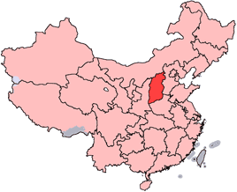
China-Shanxi.png


The earthquake occurred near Huaxian, Shaanxi (formerly Shensi), China, about 50 miles (80 km) east-northeast of Xi'an, the capital of Shaanxi. More than 830,000 people were killed. Damage extended as far away as Taiyuan, the capital of Shanxi (formerly Shansi) and about 270 miles (430 km) northeast of the epicenter. There are felt reports as far away as Liuyang in Hunan, more than 500 miles (800 km) away. Geological effects reported with this earthquake included ground fissures, uplift, subsidence, sandblows, liquefaction and landslides. Most towns in the damage area reported city walls collapsed, most to all houses collapsed and many of the towns reported ground fissures with water gushing out (ie. liquefaction and sandblows). Gu, et.al. says that "the identified death toll of soldiers and civilians was 830,000, and the unidentified was uncountable." The earthquake was felt in all or parts of 9 provinces: Anhui, Gansu, Hebei, Hubei, Henan, Hunan, Shaanxi, Shandong and Shanxi. The maximum intensity is XI in the Huaxian-Weinan area and the estimated magnitude is 8.
Additional details from Gu, et.al.:
In Huaxian, "city walls, temples, offices and civilian houses were demolished, without a single wall left standing.... The ground fissured and sunk. Water gushed out and formed canals. Sixty percent of the people (several tens of thousands were killed or injured."
In Weinan [15 miles (24 km) west of Huaxian], "city walls, temples, storehouses, offices and civilian houses collapsed totally.... In the city, the ground sunk for more than 3 meters. Fifty percent of the people were killed."
In Xi'an [one of China's major cities then as it is now], "city walls, storeyed buildings and terraces collapsed. Most temples were destroyed. More than half of the houses toppled down. Only 10-20 percent of the walls were left standing. The ground fissured crisscross. Thirty percent of the people were killed."
Even as far away as Taiyuan, "houses were destroyed in great numbers."
sursa
 
Megaseismul de subductie din Cascadia

"Cascadia Subduction Zone Megathrust Earthquake 26 Jan 1700" reminder
When
Monday, 26 January 2015
08:00 AM to 09:00 AM
(GMT) Greenwich Mean Time - Dublin / Edinburgh / Lisbon / London
Where
USA Pacific Northwest Cascadia Subduction Zone
Notes
Cascadia Subduction Zone Megathrust Earthquakes
Orphan Tsunami of 1700


Yahoo Groups WorldEarthquakes

[WorldEarthquakes] Cascadia Subduction Zone Megathrust Earthquake 26 Jan 1700, Monday, 26 J

A fost un megaseism de magnitudine estimata Mw 9 care a generat un tsunami distrugator, cu efecte inclusiv pe coasta Japoniei.
 
CaliforniaDisasters California's Earthquake Forum Geology2 AllThingsHistory
Jan 26 at 9:37 PM


Cascadia Subduction Zone
1700 01 26
Magnitude ~9

This earthquake, the largest known to have occurred in the "lower 48" United States, rocked Cascadia, a region 600 miles long that includes northern California, Oregon, Washington, and southern British Columbia. The earthquake set off a tsunami that not only struck Cascadia's Pacific coast, but also crossed the Pacific Ocean to Japan, where it damaged coastal villages. Written records of the damage in Japan pinpoint the earthquake to the evening of January 26, 1700.

The M9 Cascadia Megathrust Earthquake of January 26, 1700

CaliforniaDisasters California's Earthquake Forum Geology2 AllThingsHistory
Today at 6:50 AM


The M9 Cascadia Megathrust Earthquake of January 26, 1700


At 9PM on January 26, 1700 one of the world's largest earthquakes occurred along the west coast of North America. The undersea Cascadia thrust fault ruptured along a 1000 km length, from mid Vancouver Island to northern California in a great earthquake, producing tremendous shaking and a huge tsunami that swept across the Pacific. The Cascadia fault is the boundary between two of the Earth's tectonic plates: the smaller offshore Juan de Fuca plate that is sliding under the much larger North American plate.

The earthquake shaking collapsed houses of the Cowichan people on Vancouver Island and caused numerous landslides. The shaking was so violent that people could not stand and so prolonged that it made them sick. On the west coast of Vancouver Island, the tsunami completely destroyed the winter village of the Pachena Bay people with no survivors. These events are recorded in the oral traditions of the First Nations people on Vancouver Island. The tsunami swept across the Pacific also causing destruction along the Pacific coast of Japan. It is the accurate descriptions of the tsunami and the accurate time keeping by the Japanese that allows us to confidently know the size and exact time of this great earthquake.

The earthquake also left unmistakeable signatures in the geological record as the outer coastal regions subsided and drowned coastal marshlands and forests that were subsequently covered with younger sediments. The recognition of definitive signatures in the geological record tells us the January 26, 1700 event was not a unique event, but has repeated many times at irregular intervals of hundreds of years. Geological evidence indicates that 13 great earthquakes have occurred in the last 6000 years.

We now know that a similar offshore event will happen sometime in the future and that it represents a considerable hazard to those who live in southwest B.C. However, because the fault is offshore, it is not the greatest earthquake hazard faced by major west coast cities. In the interval between great earthquakes, the tectonic plates become stuck together, yet continue to move towards each other. This causes tremendous strain and deformation of the Earth's crust in the coastal region and causes ongoing earthquake activity. This is the situation that we are in now. Some onshore earthquakes can be quite large (there have been four magnitude 7+ earthquakes in the past 130 years in southwest B.C. and northern Washington State). Because these inland earthquakes can be much closer to our urban areas and occur more frequently, they represent the greatest earthquake hazard. An inland magnitude 6.9 earthquake in 1995 in a similar geological setting beneath Kobe, Japan caused in excess of $200 billion damage.

Source: http://www.earthquakescanada.nrcan.gc.ca/histor/15-19th-eme/1700/1700-eng.php

Tonight at about 9 P.M. in the year 1700 the Great Cascadia Earthquake of January 26, 1700, rocked the region that would become to be known as the Pacific Northwest, a quake that was perhaps as large as the 2004 Indian Ocean Earthquake. This quake, which ruptured a mega-thrust fault zone that runs from Cape Mendocino in Northern California northwards to Vancouver, British Columbia triggered a Pacific-wide tsunami that struck the coast of Japan where it was recorded as an "orphan tsunami" as there was no quake in Japan to which the Japanese could connect it. Although the only inhabitants of the epicenter region were pre-Columbian aboriginal peoples (First Nations) they also kept a record of this event in their oral traditions and both this record and the Japanese one are supported by ample multidisciplinary scientific evidence which all blends together to tell a frightening tale of Winter nighttime terror starting with sound and motion and ending with cold frothy dark waters. How large the tsunamis were that struck that night is anybody's guess but one can assume that they averaged at least in the 30 foot or higher run-up range with some zones hit with higher run-ups than others. There can be no doubt that most if not all of the area that would later come to be known as California felt this quake whose shaking would have gone on for several minutes or more. There can also be no doubt that the entire length of the future California coast was struck by dangerous if not deadly tsunami run-ups given the height of the run-ups resulting from the Great Alaska Quake of March, 1964, which was much further away. When this event happens again, IF our civilization is still here when it happens it will be devastating and deadly and cause damage and upheaval perhaps on a level not seen in our nation since the Civil War.

[californiadisasters] 1700 Cascadia Great Earthquake, Tuesday, 27 January 2015
 
La 4 februarie 1975 a avut loc o premiera in seismologia mondiala, practic prima previziune reusita a unui cutremur major. Seismul a avut loc in China, provincia Haicheng-Liaoning, a avut magnitudinea 7,3 si a fost anticipat prin precursori biologici, geofizici si seismici. Populatia din localitatile apropiate de epicentru a fost evacuata cu pana la 12 ore inainte. Totusi, nu s-a putut evita un anumit numar de victime, mult mai mic insa decat daca seismul nu era anticipat.
In prognoza acestui cutremur s-au avut in vedere variatii pe termen lung in seismicitate, inclusiv tendinta de deplasare a epicentrelor cutremurelor majore incepand din 1969, apoi aparitia unor socuri precursoare moderate incepand din decembrie 1974, deformari ale crustei terestre, comportamente neobisnuite ale animalelor, mai ales serpii care ieseau in masa de sub zapada.
 
La 4 februarie 1976 a avut loc un cutremur catastrofal in Guatemala, unul dintre cele mai grave produse in aceasta tara in ultimii 100 de ani. Seismul a avut magnitudinea Mw 7,5 si s-a produs pe falia Montagua, o fractura majora care, de-a lungul timpului, a fost sursa a numeroase seisme mari in Guatemala. Este o falie de decrosare intre placa Nord-Americana si placa Caraibiana.

http://en.wikipedia.org/wiki/1976_Guatemala_earthquake
 
9 februarie 1971, cutremur puternic de magnitudine 6,6 in California, zona San Fernando-Sylmar, langa Los Angeles

Occurred in a sparsely populated area of the San Gabriel Mountains, near San Fernando. It lasted about 60 sec., taking 65 lives, injuring more than 2,000, causing property damage estimated at $505 million. The earthquake created a zone of discontinuous surface faulting, named the San Fernando Fault Zone, which partly follows the boundary between the San Gabriel Mountains the San Fernando - Tujunga Valleys partly transects the northern salient of the San Fernando Valley. This latter zone of tectonic ruptures was associated with some of the heaviest property damage sustained. Within the entire length of the surface faulting, which extended roughly east-west for about 15 km., the maximum vertical offset measured on a single scarp was about 1 meter, the maximum lateral offset about 1 meter, the maximum shortening (thrust component) about 0.9 meters. The most spectacular damage included the destruction of major structures at the Olive View the Veterans Administration Hospitals collapse of freeway overpasses. The newly built, earthquake-resistant buildings at the Olive View Hospital in Sylmar were destroyed - 4 five-story wings pulled away from the main building 3 stair towers toppled. Older, unreinforced masonry buildings collapsed at the Veterans Administration Hospital at San Fernando, killing 49 people. Many older buildings in the Alhambra, Beverly Hills, Burbank, Glendale areas were damaged beyond repair, thousands of chimneys were damaged in the region. Public utilities facilities of all kinds were damaged, both above below ground. Severe ground fracturing landslides were responsible for extensive damage in areas where faulting was not observed. The most damaging landslide occurred in the Upper Lake area of Van Norman Lakes, where highway overpasses, railroads, pipelines almost all structures in the path of the slide were damaged severely. Overpasses collapsed. Lower Van Norman Dam Pacoima Dam were damaged severely.

Grup de discutie Yahoo Groups: WorldEarthquakes Calendar
[email protected]
 
13 februarie
M 7.4 - Shantou, China, 1918
1,000 dead. One of the world's deadliest earthquakes.
Most houses destroyed and 80% of the population was killed or wounded on Nan'ao. About 1,000 people killed or injured at Shantou (Swatow). More than 90% of houses destroyed or damaged in the Jieyang-Yunxiao area of Guangdong and Fujian Provinces. Damage occurred as far away as Fuzhou (Foochow). The death toll may be as high as 10,000, but is difficult to count since the source combines deaths and injuries and often gives percentages instead of specific numbers. The quake was felt in Anhui, Fujian, Guangdong, Guangxi, Hubei, Hunan, Jiangsu, Jiangxi, Taiwan and Zhejiang Provinces.

M 6.6, d=14 km - El Salvador, 2001
At least 315 people killed, 3,399 injured and extensive damage. The most severe damage occurred in the San Juan Tepezontes-San Vicente-Cojutepeque area. Landslides occurred in many areas of El Salvador. Felt throughout El Salvador and in Guatemala and Honduras.
 
[California's Earthquake Forum] 1933 M 6.4 Long Beach, CA, Tuesday, 10 March 2015
Social
[email protected]
To
[email protected]

alt
"1933 M 6.4 Long Beach, CA" reminder
When
Tuesday, 10 March 2015
11:00 AM to 11:00 AM
(GMT) Greenwich Mean Time - Dublin / Edinburgh / Lisbon / London
Where
Long Beach, California
Notes
10 March 1933, 120 dead; $40 million in property damage, estimated magnitude 6.25 Ms, Intensity VIII, occurred at 5:55 p.m., March 10, 1933. The rupture occurred on the Newport-Inglewood-Rose Canyon Fault Zone. Engineered buildings and reinforced concrete buildings sustained little or no structural damage. Brick buildings with unreinforced masonry walls, including many of the school buildings, failed catastrophically. If the quake had struck a few hours earlier, when school was in session, the loss of life would have been appalling. As it was, 120 people died in the quake largely from collapsed houses and small buildings or falling debris, including 5 children who died in failed gymnasium. The school buildings damaged or destroyed were of an "irregular shape," built of brick and not designed to resist any lateral stress. As well, part of the failure of the brick buildings was due to shoddy workmanship and inferior mortar. Several of the failed school buildings were designed with elaborate entrance towers that collapsed in a hail of bricks and architectural ornamentation. Reinforced concrete school buildings survived the quake with no structural damage. As a direct result of the structural failures of unreinforced masonry schools, earthquake-resistant design and construction were mandated for public schools: K-12 and community colleges. This was due largely to the efforts of California Assembly Member, Charles Field and the law, known as the Field Act was passed on April 10, 1933. It and its subsequent revisions authorized the Division of Architecture of the California State Department of Works to review and approve all public school plans and specifications and to furnish general supervision of the construction work. No Field Act school has ever failed in an earthquake. http://earthquake.usgs.gov/earthquakes/states/events/1933_03_11.php http://nisee.berkeley.edu/long_beach/long_beach.html
 
Acum 4 ani a avut loc megaseismul de magnitudine 9,0 (Mw) din nord-estul insulei Honshu, Japonia, cel mai mare cutremur produs in Japonia in ultimii cel putin 1000 de ani. Epicentrul megaseismului a fost situat intr-o zona in care, aparent, ei nu prea se asteptau, desi in 1933 avusese loc un cutremur mare la Sanriky, un pic mai la sud, cred (Mw 8,5). Si atunci a fost un tsunami catastrofal.
De remarcat faptul ca megaseismul a fost precedat de o intensificare a activitatii seismice in zona, chiar cu mai multe luni; pe 9 martie 2011 s-a produs un cutremur major de magnitudine Mw 7,2 urmat de altele de magnitudini 6-6,2 in aceeasi zona, pana la megaseismul din 11 martie.
 
Unul dintre cele mai mari si mai adanci seisme inregistrate in Europa, a avut loc acum fix 61 de ani:
his_1954_03_29.gif

M7.9 - Spain, 1954
The earthquake occurred in the south of Spain, and caused property damage at Malaga. Felt at Madrid, Granada and Cadiz, Spain; Tangier, Spanish Morocco, and Casablanca, French Morocco. The depth was 640 kilometers.
sursa: USGS.gov
Dupa alte surse cutremurul ar fi fost ceva mai mic.
 
M 6.9 Muntenegru (ex Yugoslavia), 1979 (Io=9,5)
250px-Relief_Map_of_Montenegro.svg.png

At least 121 people reported killed, more than 1,000 injured, 100,000 reported homeless, and extensive damage along the southwestern coast of Yugoslavia. Thirty-five people killed, 400 injured, and extensive damage in northern Albania. Also felt over a wide area of Europe. Tsunami reported in Kotor Bay causing considerable damage. A number of aftershocks followed, one reaching a magnitude 6. Many of the aftershocks caused additional damage and injuries.

Cutremur resimtit si in Oltenia si Banat

Detalii despre acest cutremur: http://unesdoc.unesco.org/images/0014/001472/147207eo.pdf
 
Back
Sus